")
")
Namibia Highlights with South of Namibia
19 Days Namibia Safari

Discover the highlights Namibia. You will visit the beautiful Kalahari Desert, the gigantic Fish River Canyon will having a sundowner on the rim, Kayak on the border of Namibia and South Africa, take a bath in the ghost town of Kolmanskop, watch the sunrise from the top of Dune 45, walk amongst an eerie forest of deadvlei, discover the living desert around Swakopmund and see the flamingoes in Walvis Bay, watch “National Geographic” live at the Etosha as well as discover the ancient art of the local people. The south is also very different in scenery than the rest of the country. Let’s inspire you to discover the South West of Namibia in just 19 DAY’s.
Höhepunkte:
- Windhoek
- Kalahari
- Quiver Tree Forest
- Fishriver Canyon
- Lüderitz
- Ghost Town Kolmanskop
- Sossusvlei
- Swakopmund
- Twyfelfontein
- Etosha
- Waterberg
- Erindi Game Reserve
DAY 1; Airport –Windhoek
On arrival you will be met by a representative of Odyssey Car & 4x4 Hire. Your tour will start by driving 42km to the Windhoek, the capital and largest city of the Republic of Namibia. You will receive a comprehensive 1-2 hours briefing of the vehicle, camping equipment & the route you will be driving.
Following this you can buy provisions in Windhoek for the next 19 days self-drive adventure. Your first night spend will be overnighting in Windhoek in a Guesthouse.
If your flight are schedule to arrive after 14H00 no vehicle handover will take place only on day 2 but you would be transferred to your first nights’ accommodation. If flights are schedule to arrive before 10H00 am we can change first night in Windhoek to first night outside Windhoek to make day 2’s driving a bit less.
Notable landmarks to visit in Windhoek are: Parliament Gardens, Christ Church (lutheran church opened in 1910, built in the gothic revivalto over style with Art Nouveau elements.), Tintenpalast (Ink Palace -within Parliament Gardens, the seat of both chambers of the Parliament of Namibia. Built between 1912 and 1913 and situated just north of Robert Mugabe Avenue), Alte Feste (built in 1890 and houses the National Museum), Reiterdenkmal (Equestrian Monument - a statue celebrating the victory of the German Empire over the Herero and Nama in the Herero and Namaqua War of 1904–1907), Supreme Court of Namibia Built between 1994 and 1996 it is Windhoek's only building erected post-independence in an African style of architecture.
Dinner at Sellenbosch Wine bar Restaurant or at Joes Beerhouse would be a wonderful start to an African experience meal.

DAY 2; Windhoek – Namib Kalahari
Today’s journey will leads you to the southern parts of Namibia via the Tropic of Capricorn, Rehoboth and Kalkrand into the center of the Kalahari Desert, well known for its red dunes.
The Kalahari Desert (in Afrikaans "Dorsland", meaning "thirst land" or "thirsty land") is a large semi-arid sandy savannah in Southern Africa extending 1.2 million square kilometers, covering much of Botswana and parts of Namibia and South Africa. As semi-desert, with huge tracts of excellent grazing after good rains, the Kalahari supports more animals and plants than a true desert, such as the Namib Desert to the west. There are small amounts of rainfall and the summer temperature is very high. The surrounding Kalahari Basin covers over 2 500 000 square kilometres extending farther into Botswana, Namibia and South Africa and encroaching into parts of Angola, Zambia and Zimbabwe. The only permanent river, the Okavango, flows into a delta in the northwest, forming marshes that are rich in wildlife. Ancient dry riverbeds—called omuramba— traverse the Central Northern reaches of the Kalahari and provide standing pools of water during the rainy season. Previously havens for wild animals from elephants to giraffes, and for predators such as lions and cheetahs, the riverbeds are now mostly grazing spots, though leopards and cheetahs can still be found. Among deserts of the southern hemisphere the Kalahari most closely resembles some Australian deserts in its latitude and its mode of formation.
Overnight in the Kalahari surroundings
DAY 3; Kalahari – Fish River Canyon
Today continue south to Keetmanshoop. While you are in Keetmanhoop you can do a visit to the Mesosaurus fossil site and the Quiver tree forest before continuing to the Fish River Canyon.
The Quiver Tree Forest is situated on the Farm Gariganus, located about 14 km north-east of Keetmanshoop. Around about 250 quiver trees can be found in this area. Scientifically named Aloe dichotoma, this unique tree has a funny story behind its name. The San people who used to populate the area, once used the branches from these trees to make their quivers. The tree was named by Simon van der Stel in 1685, after he heard the story about the quivers. Something that makes this tree very interesting as well, is the fact that it looks like they grow upside down. This is because of the leaves that look very much like roots. It is also believed that these trees have a ‘holy’ status in some local religions.
The Mesosaurus is probably one of the most convincing examples to prove the drifting of continents. The same genus in the same rock formations is to be found in both southern Africa and South America. In southern Africa the fossils can be found in the Whitehill formations, while in South America they are to be found in the Irats formations.
Overnight in the Fish River Canyon surrounding
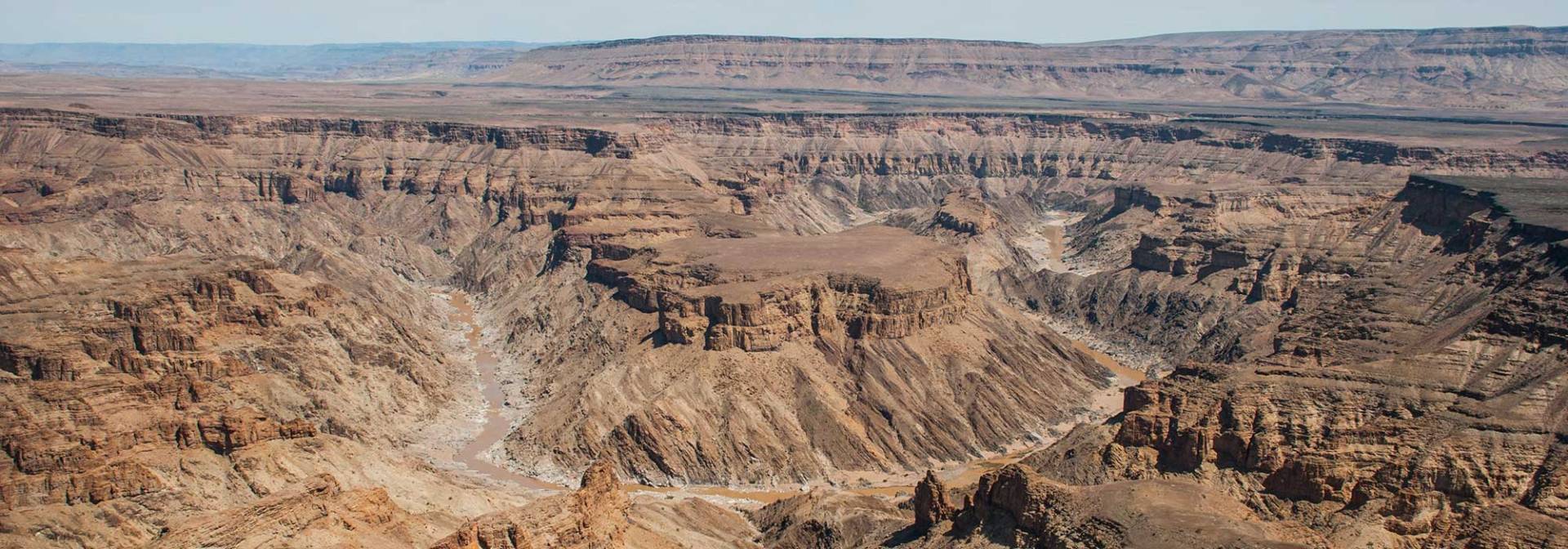
DAY 4; Fish River Canyon
Use this day to explore the wonderful and magical surrounding area and visit the main viewpoint of the fish river canyon
For the ones with good physical condition, an 85 km hike can be taken starting from the Hiker’s viewpoint and will last for about 4 days. A permit is mandatory and can be organized with NWR in Windhoek. The hiking trail is open only during the winter months from May to September. It is definitely not for sissies. Day hikes are not allowed into the canyon.
With 160 km in length, the Fish river canyon is considered the second longest canyon in the world, after the world famous Grand Canyon. The Fish River is the longest interior river in Namibia. It cuts deep into the plateau which is today dry, stony and sparsely covered with hardy drought-resistant plants. The river flows intermittently, usually flooding in late summer; the rest of the year it becomes a chain of long narrow pools. At the lower end of the Fish River Canyon, the hot springs resort of Ai-Ais is situated.
Ai Ais means “place of burning water” in the local Nama language and is an oasis of natural thermal springs found in the area. The hot springs are now part of the Ai-Ais Richtersveld National Park, which is shared between Namibia and South Africa.
A visit to the hot springs resort is worthwhile to wash off the desert sand or just to relax in the warm and enjoyable thermal waters either indoors or out.
Overnight in the Fish River surroundings
Day 5; Fish River Canyon – Orange River
Today your journey will take you to the border of Namibia and South Africa to the Orange River
The Orange (now called Gariep) river seeps like a green lung through the south of Namibia. The Orange River marks the border between South Africa and Namibia. The fertile river banks stand in strong contrast with the Desert Mountains on the South African side and the dry vast Namib Desert on the Namibian side. The Orange River is the longest river in South Africa and the Orange River Basin extends extensively into Namibia and Botswana to the north. It rises in the Drakensberg Mountains in Lesotho, flowing westwards through South Africa to the Atlantic Ocean. The river forms part of the international borders between South Africa and Namibia and between South Africa and Lesotho, as well as several provincial borders within South Africa. Except for Upington, it does not pass through any major cities. The Orange River plays an important role in the South African economy by providing water for irrigation and hydroelectric power. The river was named by Robert Jacob Gordon after the Dutch Royal House. Other names include Gariep River (used by the Khoi people, Groote River or Senqu River (used in Lesotho).
The best ways to explore is by means of a famous day tour or go on a multi-day kayak, rafting or canoeing on the river, with sleeping on the river banks. I would say, enjoy the spectacular nature, the relaxed environment and the great bird sightings. The kayaking is such a fun thing to do in Namibia, and it gives you at the same time the feeling you are visiting two countries at once. Even just a few hours on the river is pleasant. The area on both sides of the river is green and lush with reeds and palm trees as well as vineyards and gives a surreal look to the stark desert landscape.
Overnight in the banks of the Orange River.
DAY 6; Orange River – Luderitz
Today you will drive to a small settlement Aus towards the coastal town of Lüderitz. Will driving to Aus/Lüderitz keep your eyes open, if you are lucky you will spot the wild horses of the Namib Desert.
Aus is a settlement in the Karas Region of southern Namibia. It lies on a railway line and the B4 national road, 230 km west of Keetmanshoop and about 125 km east of Lüderitz and belongs to the ǃNamiǂNûs electoral constituency. Trains from Keetmanshoop now terminate at the village but formerly continued on to Lüderitz. The settlement is small but has a number of amenities including a hotel, police station, shop and garage. It is located in the Aus Mountains above the plains of the Namib Desert. The climate is usually hot and arid but snow has been recorded in winter in 1963.The village was formerly the site of a prisoner-of-war camp established by the South African army in 1915 to house German inmates captured during the First World War. The inmates initially lived in tents but later built brick houses. The number of prisoners reached 1500 but by May 1919 the last inmates left and the camp closed. A plaque marks the site today and some of the houses have been reconstructed. The area west of Aus is noted for its herd of feral horses living in the desert. Their origin is uncertain but today there is a population of between 150 and 200 individuals which have adapted to the harsh environment. They urinate less than domestic horses and can go five days without water. They drink at an artificial water hole at Garub Pan where a blind has been erected to enable tourists to watch the animals without disturbing them.
Overnight in the small coast town Luderitz
DAY 7; Luderitz / Kolmanskoppe
Explore the harbour town and the surrounding area today. You can drive to the ancient diamond ghost town Kolmanskuppe or travel along the coastline to visit the Diaz Point and the bays along the way. In town, you can go to the museum, the Goerke House or the ‘Felsenkirche’. Do you maybe want to book a guided tour to the Rock Arch or visit Elisabeth Bay in the restricted diamond area? What about a boat cruise to a penguin island?
Luderitz is a quirky town lodged in one of the best harbours on the least hospitable coast in Africa. It was founded in 1883 when Heinrich Vogelsang purchased Angra Pequena and some of the surrounding land on behalf of Adolf Lüderitz, a hanseat from Bremen, from the local Nama chief. It began life as a trading post, fishing and guano-harvesting town, but when diamonds were discovered in 1909 in nearby Kolmanskop, Lüderitz and joyed a sudden surge of prosperity. Now the diamonds are mostly found elsewhere and offshore, so Lüderitz has reverted to its former self. Its appeal as a town lies in the fact that little has changed since the early 20th century (and in fact it has hardly grown at all)
Overnight again in the small coast town
DAY 8; Luderitz / Aus – Sesriem
You will have to return to Aus and straight away join the small desert roads that connect the whole of rural Namibia. En-route you can visit the Duwisib Castle which was built in the middle of nowhere.
Duwisib Castle, sometimes spelt Duwiseb or Duweseb, is a grand pseudo-medieval looking fortress in the hills of the semi-arid Southern Namib region of Namibia. It was built by 'Baron' Captain Hans Heinrich von Wolf (born in Dresden, 1873), who was posted to (then) German South-West Africa. After the German-Nama war Captain von Wolf went home to Dresden and married the stepdaughter of the US consul, Miss Jayta Humphreys, on 8 April 1907. They decided to settle in German South-West Africa and bought eight farms in the Maltahöhe area. Eminent architect Wilhelm Sander was commissioned to design a building and construction commenced in 1908. Most materials were imported from Germany and stonemasons were hired from Italy, Sweden and Ireland.It was hoped that the castle would bear a resemblance to some of the existing German Forts in Namibia. Much of the raw materials for the construction of the fort were imported from Germany, landing at Lüderitz. The resulting edifice consisted of 22 rooms.While they were travelling to Europe in 1914, the First World War broke out and the ship carrying Von Wolf and his wife was diverted to Rio de Janeiro. Jayta Humphreys had retained her American citizenship and found passage to Europe on a Dutch ship; legend has it the Baron had to travel disguised as a woman. On arrival in Europe the Baron rejoined the German army, and was killed at the Battle of the Somme in 1916, just two weeks after signing up. His wife could not bring herself to return to Namibia alone and never again laid claim to the majestic castle. She spent the rest of her life in the South of England. What are said to be descendants of their fine thoroughbred horses can be seen today roaming free and wild as Namib Desert Horses along the roadside and in the restricted diamond areas, although whether this is the origin of these herds is not accurately known.The property is currently under the management of Namibia Wildlife Resorts.
Namib Naukluft Park: One of Africa’s largest and oldest protected areas, the Namib - Naukluft National Park covers an area of almost 50,000 km2 and protects some of the most varied and extraordinary ecosystems in Namibia; the only country in the world named after its desert!
Overnight in the Sesriem surrounding.
DAY 9; Sossusvlei / Solitaire
Today will be an early morning you can enjoy the fantastic sight of the Sossusvlei Dunes the world’s highest dunes, the dead vlei and Sesriem Canyon.
The best time to view Sossusvlei is close to sunrise and sunset, when colours and shades change constantly, offering a photographer’s dream. The midday heat is intense and best spent in the shade. Sossusvlei (sometimes written Sossus Vlei) is a salt and clay pan surrounded by the highest sand dunes in the world, the highest reaching 300–400 meters (350m on average, named "Big Daddy" or "Crazy Dune"), which rest on a sandstone terrace. Located in the southern part of the Namib Desert, in the Namib-Naukluft National Park of Namibia. The name "Sossusvlei" is of mixed origin and roughly means "dead-end marsh". Vlei is the Afrikaans word for "marsh", while "sossus" is Nama for "no return" or "dead end". Sossusvlei owes this name to the fact that it is an endorheic drainage basin (i.e., a drainage basin without outflows) for the ephemeral Tsauchab Riv
The clay pan was formed after rainfall, when the Tsauchab river flooded, creating temporary shallow pools where the abundance of water allowed camel thorn trees to grow. When the climate changed, drought hit the area, and sand dunes encroached on the pan, which blocked the river from the area.The trees died, as there no longer was enough water to survive. There are some species of plants remaining, such as salsola and clumps of nara, adapted to surviving off the morning mist and very rare rainfall. The remaining skeletons of the trees, which are believed to have died 600–700 years ago (ca. 1340-1430), are now black because the intense sun has scorched them. Though not petrified, the wood does not decompose because it is so dry.
The name Sesriem is Afrikaans and means "six belts", given by settlers on the Dorsland Trek who had to attach together six belts (made of oryx hides) in order to reach buckets down into the canyon to scoop up water. Sesriem Canyon is only two metres (6.5 feet) wide in some places, and has a portion that permanently contains water, which many animals use. It is a natural canyon carved by the Tsauchab river in the local sedimentary rock, about a kilometre (0.6 mile) long and up to 30 meters (100 feet) deep.
Again, Overnight in the Sesriem surroundings
DAY 10: Solitaire – Walvis Bay - Swakopmund
Once again, the route leads you to the coast of Namibia. Drive via Solitaire where you have to stop for the world’s famous apple strudel.
Solitaire is a small settlement in the Khomas Region of central Namibia near the Namib-Naukluft National Park. It currently features the only gasoline station, bakery, cafe, and the only general dealer between the dunes at Sossusvlei and the coast at Walvis Bay, as well as to the capital Windhoek. Solitaire belongs to the Windhoek Rural electoral constituency. Solitaire is known in The Netherlands because of the book of the same name by Dutch author Ton van der Lee dealing with his stay in this place.
Overnight in the town of Swakpmund
DAY 11; Walvis Bay / Swakopmund
Today is yet another leisure day to participate in some activities. (Please book activities with us in advance).
Swakopmund (German for "Mouth of the Swakop River") is the ideal holiday destination of Namibia which lies on the west coast only 350km from Windhoek. Swakopmund was founded in 1892 as the main harbour for German South-West Africa, and a sizable part of its population is still German-speaking today. Boats were offloaded at Swakopmund’s landmark, the jetty. However, the natural potential of Swakopmund as a holiday resort was recognized, and this potential has subsequently been developed. Today tourism-related services form an important part of the town's economy. This little town is rich in beautiful German colonial architecture/buildings, e.g. the beautiful old train station which was converted into a hotel, the prison, the Woerman House which used to be the head office of the Woermann Line (colonial shipping line) and now houses the public library and shops, the Light House, the Jetty which now houses a restaurant, just to mention a few. Swakopmund has an excellent museum on the history of Namibia / Southwest Africa. Swakopmund has a lot to offer which include attractions like the National Marine Aquarium, the Crystal Gallery, the Martin Luther Steam locomotive and “things to do” like fishing, dolphin cruise, snake park, skydiving and quad biking, dune riding, ballooning, camel riding and excellent shopping possibilities.
Again, Overnight in one of Swakopmunds fabulous Guesthouse. Restaurants to try out in Swakopmind, Jetty 1905, Swakopmund Brauhaus, The Tug, kucki’s Pub, Tiger reef.
DAY 12; Swakopmund - Twyfelfontein
Today you will be driving partly along the coast line before heading inland to Damaraland region with its vast and rugged terrain. On your way you can stop at the seal colony at Cape Cross, which is home to the largest breeding colony of Cape Fur Seals in the world. (During breeding season in November and December up to 210.000 seals gather to mate, breed and fish in the rich waters of the Benguela current. Imagine the cacophony of sounds and smells which at times can be overwhelming. Nevertheless if you want to see nature in its purest form, it is worthwhile to drive along the Skeleton Coast to visit this Seal reserve at Cape Cross.) You will also be passing the Brandberg Mountain, Namibia’s highest mountain which you can also have a quick stop and explore.
Cape Cross (Afrikaans: Kaap Kruis; German: Kreuzkap; Portuguese: Cabo da Cruz) is a small headland in the South Atlantic in Skeleton Coast, western Namibia. The Portuguese navigator and explorer Diogo Cão was in 1484 ordered by King João II, as part of the search for a sea route to India and the Spice Islands, to advance south into undiscovered regions along the west coast of Africa. While doing so, he was to choose some particularly salient points and claim them for Portugal by setting up on each a stone cross called padrão. The original Cape Cross padrão was removed in 1893 by Corvette captain Gottlieb Becker, commander of the SMS Falke of the German Navy, and taken to Berlin. A simple wooden cross was put in its place. The wooden cross was replaced two years later by a stone replica. At the end of the 20th century, thanks to private donations, another cross, more similar to the original one, was erected at Cape Cross, and thus there are now two crosses there.
Damaraland is one of the most scenic areas in Namibia, a huge, untamed, ruggedly beautiful region that offers the more travelers a more adventurous challenge. Here there are prehistoric water courses with open plains and grassland, massive granite koppies and deep gorges. Towards the west, the geography changes dramatically with endless sandy wastes, that incredibly are able to sustain small, but wide-ranging, populations of desert-adapted elephant, black rhino, giraffe, ostrich and springbok. These animals have adapted their lifestyles to survive the harshness of the sun-blistered, almost waterless desert spaces. Elephant move through euphorbia bush country, and can travel up to 70km in a day in search of food and water and unusually, do not destroy trees in their quest for food.
Overnight in the Brandberg surrounding
DAY 13; Twyfelfontein / Organ Pipes / Petrified Forest – Etosha
It’s time to explore one of the World Heritage Sites, Namibia has to offer – Twyfelfontein with its wealth of ancient rock engravings, and the wonders of the Organ Pipes before hiding to Etosha. On your way to the Etosha National Park, you may also want to visit the Petrified Forest. Your journey then continues via Khorixas and Outjo to your next stop over, just south of the Anderson Gate.
Twyfelfontein valley has been inhabited by Stone-age hunter-gatherers of the Wilton Stone Age culture group since approximately 6,000 years ago. They made most of the engravings and probably all the paintings. 2,000 to 2,500 years ago the Khoikhoi, an ethnic group related to the San (Bushmen), occupied the valley, then known under its Damara/Nama name ǀUi-Ais (jumping waterhole). The Khoikhoi also produced rock art which can clearly be distinguished from the older engravings
The Petrified forest located some 40 kilometres west of the Namibian town of Khorixas, on the C39 road, is a deposit of large tree trunks that have "turned to stone" through a process of diagenesis. There at least two large tree trunks exposed to view and more may be out of sight. The site was declared a National Monument on 1 March 1950. It is believed that the trees were swept downstream by a large flood and covered by alluvial sands. Deprived of air, the organic matter could not rot and decay, but instead, over millions of years, underwent silicification, whereby each cell is individually fossilised and the appearance, if not the colour, of wood is retained. The surrounding sands became sandstone, which is now eroding away. In addition, there are a large number of welwitschia plants at the site. Public access is by guided tour only. There are toilet and refreshment facilities.
Overnight close to the Etosha Park
DAY 14 & 15 Etosha / Okaukuejo / Halali / Namutoni
You have two (2) full day, which you can use to explore the abundant wildlife in the Etosha Park, Namibia has to offer. All this in the comfort of your own vehicle.
The park is home to hundreds of species of mammals, birds and reptiles, including several threatened and endangered species such as the black rhinoceros.
ETOSHA NATIONAL PARK is the gateway to Northern Namibia and Ovamboland. It is Namibia’s prime wildlife location and home to a large variety of mammals and birds. Etosha means the ‘great white area ‘this refers to large dried pan in the middle of the Etosha Park. What makes this park unique is the floodlit waterholes at all the main camps. Visit Etosha National Park in Namibia this season and share in Namibia’s wildlife. Etosha Park is any photographers dream. Plan your visit to Namibia and experience the great white area of Etosha. The park was proclaimed a game reserve on March 22, 1907 in Ordinance 88 by the Governor of German South West Africa, Dr. Friedrich von Lindequist.
Overnight in Etosha Park
DAY 16; Etosha – Waterberg
Today you will drive through Tsumeb and Grootfontein to Waterberg for your next destination. On your way to the Waterberg you can have a stop to visit the Hoba meteorite.
The Hoba meteorite left no preserved crater and its discovery was a chance event. The owner of the land, Jacobus Hermanus Brits, encountered the object while ploughing one of his fields with an ox. During this task, he heard a loud metallic scratching sound and the plough came to an abrupt halt. The obstruction was excavated, identified as a meteorite and described by Mr. Brits, whose report was published in 1920 and can be viewed at the Grootfontein Museum in Namibia. In an attempt to control vandalism and with permission from Mrs. O. Scheel, owner of the farm at the time, the government of South West Africa (now Namibia) on March 15, 1955, declared the Hoba meteorite to be a national monument.[5] In 1979 the proclamation was changed to include not only the meteorite but also 25 m x 25 m land on which it is situated.[6] In 1985 Rössing Uranium Ltd. made resources and funds available to the Namibian government to provide additional protection against vandalism. In 1987 Mr. J. Engelbrecht, the owner of Hoba West farm, donated the meteorite and the site where it lies to the state for educational purposes. Later that year, the government opened a tourist centre at the site.[6] As a result of these developments, vandalism of the Hoba meteorite has ceased and it is now visited by thousands of tourists every year
The Waterberg Plateau Park is ecologically diverse and rich and has over 200 different species of bird with some rare species of small antelope on the lower hills of the mountain. Geologically, the oldest rock stratum is over 850 million years old and dinosaurs tracks were left there some 200 million years ago.
Afternoon leisure, hiking, game watching, breathing in history or just enjoying the peaceful scenery of the Waterberg.
Overnight at the Waterberg Plateau Park.
DAY 17; Waterberg – Erindi
You can do a morning hike to the Waterberg if you did not have the chance to do it the previse day. Todays are only a short travelling, you will travel to the Erindi Private Game Reserve located southeast of Omaruru.
Erindi is a protected reserve in central Namibia. Erindi, meaning “place of water”, is a sustainable natural wonderland. The land on which Erindi was founded, has been reclaimed as part of a massive rehabilitation and conservation venture. The owners, Chris and Gert Joubert, originally bought the 70 719 hectares of land with the intention of going into cattle farming. It was soon realized that farming cattle is an extremely costly practice, and they abandoned the idea in favor of a private game reserve. The aim was to restore endemic species to the area, with the hope that they would once again thrive there.
You can join on some of the activities Erindi have to offer or just relax next to the swimming pool and enjoy the surrounding.
Overnight in the surrounding of the Erindi Private Game Reserve.
DAY 18; Erindi – Windhoek
Today you drive back to Windhoek, where you will spend your last night. On arrival in Windhoek you need to drop off your rental vehicle and will then be transferred to your accommodation. Last shopping spring to Windhoek’s Craft Centers for gift/ souvenirs for back home.
If you have a flight back home on the same day you will then be transferred to the airport the same day.
For a farewell dinner have a local Namibian game meat dinner at Joe’s Beerhouse in Windhoek for the last Namibia feeling.
Overnight in Windhoek Guesthouse
DAY 19; Windhoek – Airport
You will be picked up at the accommodation and taken to the airport for the departure flight back home
*** Hope to see you again soon ***
